Quantcast
Channel: Gründerzeit – PANORAMASTREETLINE

Rosa-Luxemburg-Strasse

$
0
0
Falkenstein Vogtland Gründerzeit FachwerkFalkenstein Vogtland Gründerzeit Fachwerk

Town History of Falkenstein

Falkenstein im Vogtland is a small town with just under 8,000 inhabitants in the Vogtland district of Saxony. It was founded in the 13th century at the foot of a castle of the bailiffs of Weida and Plauen. Initially a mining town, Falkenstein transformed itself into a textile workers’ town in the 18th century. The textile industry in Falkenstein was dominated by weavers and, later, by the production of curtains.

Wilhelminian period/Historicism

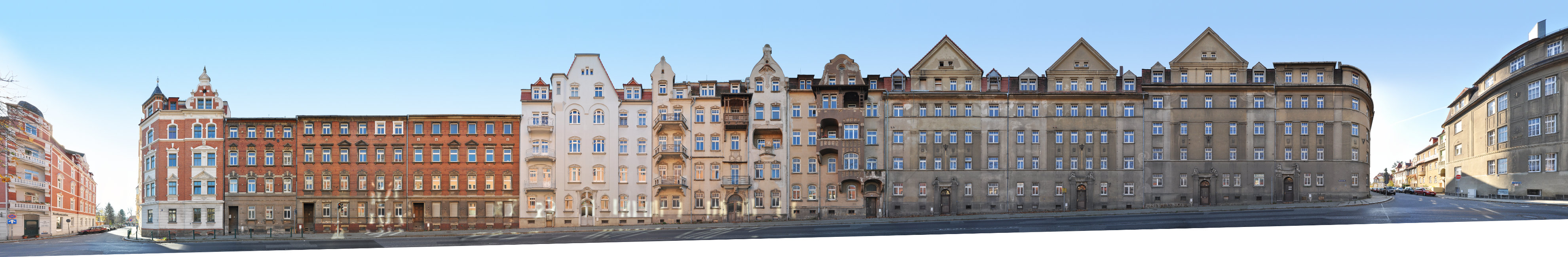
In August 1859 there was a devastating fire in Falkenstein which destroyed almost the entire town. As a result, the town was rebuilt with a planne town structure. In the late 19th and early 20th centuries, buildings in various styles of the Wilhelminian period (Gründerzeit) and historicism were erected. Here in the Rosa-Luxemburg-Street, the buildings with historicist half-timbered decorative gables are particularly striking. In the course of the reconstruction of the city, a representative town hall with Art Nouveau elements followed in 1903 and in 1912 the railway station building that still exists today.

The post Rosa-Luxemburg-Strasse appeared first on PANORAMASTREETLINE.


Masarykova | Shopping Street

$
0
0
Shopping Street Masarykova in Brno, Ceska, Cesko, Czech Republic, MoraviaShopping Street Masarykova in Brno, Ceska, Cesko, Czech Republic, Moravia

Masarykova | Shopping Street

Masarykova street is the major shopping street in the centre of Brno, connecting the train station with the Freedom Square. It has been established as a main trade route as early as the 12 th century and was once called Ferdinand Street. After the end of the monarchy it was renamed, commemorating Tomáš Garrigue Masaryk, the first president of Czechoslovakia. All buildings in the street were errected after industrialisation between the late 19th and early 20th century. This street block is shaped by a number of expressive facades. The corner building on the left (Nr. 7) was designed in Art Nouveau style by architect Leopold Bauer. The modern functionalist building on the right edge was designed by Otto Eisler.

This street view can be extended by further blocks to the left or right using archive material.

The post Masarykova | Shopping Street appeared first on PANORAMASTREETLINE.

Aeussere Bautzner Strasse

$
0
0
Löbau Straßenfront Gründerzeit Altbau unsaniertLöbau Straßenfront Gründerzeit Altbau unsaniert

We are looking at the south side of Äussere Bautzner Strasse between Pestalozzistraße on the left and Goethestraße on the right edge of the picture. The street is not far from the old town centre of Löbau, which is only another street block away on the left.

Accordingly, it is easy to see here how the town was expanded from left to right (out of town) during industrialisation and how the architectural styles changed in the process.

Building history

The two corner buildings on the left were built in the 1890s as historicist buildings with elaborate clinker brick facades and corner-emphasising turrets or gabled houses. They are followed to the right by further 1890s clinker brick buildings. House No. 19, here lightly plastered, already shows Art Nouveau elements and was built around 1905. The two following buildings (21, 23) were also built around 1905 and show elaborately designed facades with Art Nouveau elements, especially floral decorative elements. This is followed by another break and, with buildings no. 25-31, a uniformly kept development typical of a housing association. The façades are structured by pilasters and show historicist figural decoration. These buildings were refurbished for the municipal housing association until 2019 and are now repainted in a lighter colour. While the renovating architects dated the group of buildings to 1927, the Löbau cultural monument list notes 1912 as the construction date.

The post Aeussere Bautzner Strasse appeared first on PANORAMASTREETLINE.

Alfred Brodauf Strasse

$
0
0
Aue Straßenzug GründerzeitAue Straßenzug Gründerzeit

History of Alfred Brodauf Street

Our panorama shows the west side of Alfred-Brodauf-Street between Ernst-Bauch-Straße (left) and Aue’s Altmarkt (right / old market). It is one of the oldest streets in Aue and was already mentioned in 1641 as Hintere Gasse. In 1897, when it was built with 20 houses, it was called Marktstrasse. Ernst Papst settled in Alfred-Brodauf-Straße with his tin coil factory. Here one could still discover a piece of “Old Aue”, which was also evidenced by the pub of the same name. Its bar, which was integrated into a huge barrel, was a striking feature.

In Alfred-Brodauf-Straße there was a lively life in crafts and trade. Among other things, the Paul Selbmann print shop/publishing house was located here, where the “Auer Tageblatt” was produced. In 1906 the street was named “Ernst Papst Straße” in honour of the entrepreneur, honorary citizen of the town and co-founder of the voluntary fire brigade, Ernst Papst. After 1945, the street was renamed Alfred Brodauf Street. He was a regional court director, LDP democrat in Dresden and a friend of the publisher Paul Selbmann.

Commercial buildings

The row of Wilhelminian-style commercial buildings was built between 1910 and 1914. The new building of the Erzgebirgssparkasse (savings bank) on the right in the picture was built in 1997. It replaced a row of two-storey old buildings that had been preserved for a long time and still characterised the Altmarkt on this side during the GDR era. The building with the grey façade to the left was built in 1911 according to plans by the architect Otto Juhrich. For decades it was the location of the specialist shop “Walter Wappler Puppen- und Damenfrisiersalon”. At the time of the photograph, we see in the shops, from left to right: lawyers Dr. Ternick & Collegen, pro Familia, Parfümerie Sophia, Wäschetraum, Café Moments, Jeans Boutique and the Sprakasse.

There is a second series of photographs of this street frontage from May 2022, a small preview of which can be found under the detailed images.

This street view is part of our exhibition project “Stadt.Bild.Aue” for the 850th anniversary of the city of Aue in the Erzgebirge.

The post Alfred Brodauf Strasse appeared first on PANORAMASTREETLINE.

Neundorfer Strasse | Historicism

$
0
0
Neundorfer Strasse Plauen Baudenkmal SpäthistorismusNeundorfer Strasse Plauen Baudenkmal Späthistorismus

Architecture

This row of houses consists of three individual houses, which were, however, planned together by the architect Alfred Illner and built in 1903/04. According to the list of monuments in Plauen, the owners of the individual buildings were Hermann Söllner, Bernhard von Wolfersdorf and Emil Erler (from left). The elaborate, picture-perfect façades in the style of late historicism contain elements of Art Nouveau and Neo-Baroque. The predominantly floral ornaments of the oriels are striking, on the right corner building also with figures and animals. The picture is additionally characterised by the dominant roof extensions with tail gables and turrets with Welsch bonnets in the corner positions.

Neundorfer Straße is an important east-west axis in Plauen. It runs over 3 km from Plauen town hall in the centre westwards through the Neundorfer Vorstadt to the Neundorf district. We see the buildings 171, 173 as well as the corner building Kasernenstraße 1 with the Westend pharmacy as business tenant.

The post Neundorfer Strasse | Historicism appeared first on PANORAMASTREETLINE.

Wettinerstrasse

$
0
0
Gründerzeit Industrialisierung in Aue, Erzgebirge, Sachsen, DeutschlandGründerzeit Industrialisierung in Aue, Erzgebirge, Sachsen, Deutschland

An der Straßenkreuzung am Altmarkt, beginnende Wettiner Straße sieht man an deren Bebauung der Häuser mit ihren vielfältigen Fassadenschmuck, das Wachsen der emporstrebenden Industriestadt Aue um 1900. 1842 wurde der Weg noch „Am Mühlgraben“ bezeichnet. Der Touristenführer spricht1906 von einer Straße mit „Großstädtischen Flair“. Nicht nur der Handel mit Delikatessen, Lebensmitteln, Drogerie, Apotheke auch das Fleischer- und Bäckerhandwerk war neben vielen anderen Gewerben mehrfach vertreten. Gaststätten wie der „Wettiner Hof“ oder „Cafe Carola“ boten mit Konzertsaal, Theater und Kino den Einwohnern der Stadt ein vielfältiges Kulturprogramm. Im weiteren Straßenverlauf siedelten sich u.a. auch die bekannten Besteckfabriken Hutschenreuter und Gottlieb Wellner an.
Der an der Straße liegende Wettiner Platz, wurde mit einer Parkanlage von Ernst Papst, als Dank für seine Erfolge mit der Herstellung von Spinn – und Webspulen, verschönert. Damit bekam die Straße die Auszeichnung „schönste Straße von Aue“.

The post Wettinerstrasse appeared first on PANORAMASTREETLINE.

Bahnhofstrasse | Hotel Blauer Engel

$
0
0
Aue Erzgebirge Straßenzug Fassaden Architektur FotografieAue Erzgebirge Straßenzug Fassaden Architektur Fotografie

Bahnhofstraße (Train Station Street) is not only an important traffic artery, but also a well-frequented shopping street. In records from 1895 it is still noted as Lößnitzer Straße, in GDR times it was called Straße der Befreiung. The residential and commercial buildings have beautiful facades. This street begins with the Hotel Blauer Engel on the left and ends at the former Temper on the right. The two buildings on the far left are still on Aue’s Altmarkt, and it is not until the third building that Bahnhofstraße begins.

Hotel Blauer Engel

The Blauer Engel hotel (Blue Angel) building dates from 1663. It was long known as David Rehm’s Gasthaus and houses the Tausendgüldenstube on the upper floor – the name refers to the story that Rehm paid a Nuremberg artist 1000 gulden to decorate it. The hotel also includes the “Lotters Wirtschaft” adventure brewery and a beer museum with Saxony’s largest collection of beer steins.

Gantenberg bank building

In the middle of the panorama we see the building complex of the linen manufacturer W. Gantenberg. First the double-crowned right part was built in 1902 by architect Max Fricke. In 1913, Gantenberg had the complex extended to the left by architect Otto Juhrich in the same style. Over the last 100 years, the building has been used by the Deutsche Kreditbank, the Deutsche Notenbank, the State Bank of the GDR and currently the Commerzbank, among others.

Further facades

On the right, the next building with half-timbered decoration was also commissioned by Gantenberg and was built in 1898 by the architect Albert Geßner. This is followed by a Wilhelminian style building by the architect Julius Bochmann and finally the once famous Café Temper at Bahnhofstraße 13 / Schulbrücke. This extends behind the inconspicuous front to the rear along Schulbrücke Street. The old post office was located on the adjacent car park on the right until the new post office was built on Postplatz. At Bahnhofstraße 9, the Albert Geßner building, Herbert Milster sold tickets for steamship trips worldwide in the 1920s, e.g. also for the HAMBURG-AMERICA-LINE.

The post Bahnhofstrasse | Hotel Blauer Engel appeared first on PANORAMASTREETLINE.

Schneeberger Strasse

$
0
0
Aue Erzgebirge Saxony Architecture PhotographyAue Erzgebirge Saxony Architecture Photography

Our streetline panorama shows Schneeberger Strasse in the centre of Aue in the Ore Mountains. Starting at the Altmarkt on the left, it runs as a main road to the crossroads on the right of the picture, crossing the Zwickauer Mulde. At the crossroads on the right, it bends to the north/north-west from the main road and continues as a small side street.

Schieck house and bridge

Schneeberger Straße is a central shopping street with a wide variety of shops and businesses. On the left at the corner of Altmarkt and Wettinerstraße is the historic Hansa-Haus, built in the Bauhaus style in 1936. To the right are several Wilhelminian-style commercial buildings dating from 1896 to 1900. On the other side of the Mulde is the residential and commercial building by Carl August Schieck (Schieck-Haus). Initially used as a plumber’s workshop, hence the guild sign on the tower of the building, the business also began selling household goods and toys and specialised in model railways. The well-known shop closed for good on 9 December 2011.

Although the bridge over the Mulde is still called the “Schieck Bridge” today, it had nothing to do with the craft business, as the correct name is actually “König-Georg-Brücke”. Formerly known as Sandbrücke, it is immortalised as a wooden bridge in the Auer town coat of arms.

The junction to the left of the Altmarkt is also well-known. The so-called “Engel-Kreuzung” was long known for its special hanging traffic lights. On 3 September 1931, Aue was given after Iserlohn and Berlin-Charlottenburg, Aue was the third city in Germany to have this traffic light.

This panorama was created for the 850th anniversary of the town of Aue in 2023.

The post Schneeberger Strasse appeared first on PANORAMASTREETLINE.


Minoritska Street Facades

$
0
0
(Deutsch) Brünn Architektur Fotografie Tschechien Panoramafotografie Lizenzfotos(Deutsch) Brünn Architektur Fotografie Tschechien Panoramafotografie Lizenzfotos

Minoritska Ulica or Minoritengasse (old) is a street in Brno’s Old Town, only one block wide. It is located southeast of the central Freedom Square (Náměstí Svobody) and is named after the Minorite Monastery with St. John’s Church, which is located on the other side of the street.

In the panorama we see one of the most beautiful Brno Old Town ensembles of houses from the Wilhelminian and Art Nouveau periods. Worth mentioning is, for example, the Charlotta Deutschova House at Minoritska 8 – the small Art Nouveau building with gilded figural decoration in the right part of the picture.

This streetline was created on the occasion of the 50th anniversary of the Leipzig-Brno town twinning.

The post Minoritska Street Facades appeared first on PANORAMASTREETLINE.

Gymnasium Alexander von Humboldt

$
0
0
Gymnasium Werdau PanoramaGymnasium Werdau Panorama

The municipal grammar school of the Saxon town of Werdau is now located in this Wilhelminian-style building, which was erected in 1889 (also recognisable by the two inscriptions 1888/1889 in the central portico). The prestigious building was initially erected for the former elementary and girls’ school and then became a regular secondary school for decades as the Pestalozzi School. Shortly after reunification, the municipal grammar school finally moved into the building in 1992, which had only introduced seventh grade the year before, and has been offering classical grammar school education from the 5th to the 12th grade ever since. Saxony has always had an eight-year grammar school (G8) up to year 12.

History of the Werdau Gymnasium

The forerunner of Werdauer Gymnasium was initially a selective school from 1860, which later became a Realschule with Progymnasium and in the 1920s a Oberrealschule (located in the former Bürgerschule on today’s Dr. Breitscheid-Platz). In 1950 it was given the name “Alexander-von-Humboldt-Schule” and from 1960 it was known as “Erweiterte Oberschule” (EOS). In 1992, it finally became a traditional Saxon grammar school and moved into the building portrayed above.

The Werdauer secondary school trial of 1951 was a significant event in the history of the town.

The post Gymnasium Alexander von Humboldt appeared first on PANORAMASTREETLINE.


Latest Images