Quantcast
Channel: Gründerzeit – PANORAMASTREETLINE
Viewing all 36 articles
Browse latest View live

August Bebel Strasse • Leipzig • Germany

$
0
0
Leipzig August Bebel Strasse

This street block panorama shows a part of the western front of the August-Bebel-Strasse in Leipzig Südvorstadt (“southern suburb”). The former Kaiser-Wilhelm-Strasse, later renamed after the communist August Bebel, developed in the late 19th century during the Gründerzeit (“founders epoch”) when the city grew to the south. The August-Bebel-Street is offering exceptional examples for Gründerzeit architecture, as quite many representational buildings were erected in the street. This panorama can only show a very small part of this. Exceptional in another way is the fact that in the street there still railway tracks are existing, while they fullfilled no target-oriented function for years.

Meanwhile we photographed ca. 75% of the August-Bebel-Straße between Körnerstraße and Richard-Lehmann-Straße, which means we will work on more parts of the street in the future or on specific request. See or Leipzig map.


Buntgarnwerke / Nonnenstrasse • Leipzig • Germany

$
0
0
Leipzig Buntgarnwerke Elster-Park

A street front panorama of the former Buntgarnwerke along Nonnenstrasse in Leipzig. Originally the area was developed by the Sächsische Wollgarnfabrik, which bought it in 1875 and transformed it into europes largest architectural complex in Wilhelminian style (german Gründerzeit era). The grand architecture we see in this photography montage by far exceeded the typical industry architecture at the time. The complex was realised by architects Pfeiffer & Händel (after 1893 Händel & Franke). The complex, which was united with other productions into the VEB Buntgarnwerke Leipzig in 1969, today is germany’s largest industrial monument. Meanwhile the complex has been redeveloped into the Elster-Park, which includes commercial spaces, restaurants, recreational facilities and flats (Elsterlofts).

There are more Leipzig streets we photographed in our archive, which you can find by yellow markers on our worldmap. In case you are interested in us creating a streetline montage for one of these streets please contact us.

Ferdinand-Lassalle-Straße • Leipzig • Germany

$
0
0
Ferdinand-Lassalle Strasse Leipzig Photo

A street view panorama of the Ferdinand-Lassalle-Strasse between Moschelesstraße and Davidstraße. Situated next to the Johannapark and close to Leipzigs’ city centre in the Bachviertel district this is one of Leipzigs most attractive living areas. The high percentage of preserved Gründerzeit architecture adds to that effect. Surprising in this street view is the symmetry of these seven buildings, which is not visible standing in the street. In reality even more tress are standing there, some of which we edited out to make anything visible at all. A good view however is offered by the 45° aerial view at Google Maps. There is also an additional panorama of the opposing park side, the Johannapark which is also a part of the larger Clara-Zetkin-Park. Both views were presented together at the Leipzig Young Contemporary inside the Clara-Zetkin-Park in september 2013. The street is named after the german politician Ferdinand Lassalle (1825-1864), one of the founders of the social democratic party of germany (SPD).

There are more Leipzig streets we photographed in our archive, which you can find by yellow markers on our worldmap. In case you are interested in us creating a streetline montage for one of these streets please contact us.

Kaiserstrasse / Gallileo / Silver Tower • Frankfurt • Germany

$
0
0
Kaiserstrasse Frankfurt Gallileo Silberturm

Kaiserstrasse (engl. emperor street) is Frankfurt’s last conserved grand boulevard from the Gründerzeit era. It connects the main station with the Rossplatz in the city centre. While the majority of buildings is indeed from the Gründerzeit era, the street scape is typically modern Frankfurt including the scyscrapers of the area. In this panorama we see the silver tower in the left background, situated on Jürgen-Ponto-Platz (the former headquarter of Dresdner Bank) and on the right the Gallileo situated directly on the corner Kaiserstrasse/Gallusanlage. We photographed two more blocks of the street continuing to the left to be finnished later.

For an overview of other documented places from Frankfurt see our Frankfurt overview.

Dittrichring | Thomaskirche • Leipzig • Germany

$
0
0
Leipzig Street Panorama old town

Dittrichring is a part of the Leipzig city circle (Leipziger Ring) around the city centre. Here we see one block of it between St Thomas church (left) and the New Town Hall (outside the panorama, right). These buildings were errected during the so called Gründerzeit (Founders Times) era in more representative style, after the city fortifications around the city were torn down and a green promenade ring was established. We see the buildings “Café Kaiserhof”, “Augustinerbräu”, “Hotel Reichshof” and the house of Leipzigs garnison commander (from left to right), all built between 1875 and 1882. At the left edge we also see the Thomaskirchhof with St Thomas church and the “Thomas-House”. At the right edge we find Ratsfreischulstrasse.

Dieser Bereich des Leipziger Rings hieß ursprünglich “An der Pleiße”, dann “Thomasring” und wurde schließlich 1917 zu Ehren des damals noch lebenden ehemaligen Leipziger Oberbürgermeisters Dr. Rudolf Dittrich umbenannt. Die Thomaskirche ist eine von Leipzigs Hauptkirchen und vor allem als Wirkungsstätte Johann Sebastian Bachs und des Thomanerchores weltweit bekannt. Zu Pfingsten 1539 predigte hier Martin Luther. Der heutige Kirchbau stammt aus dem 15. Jahrhundert, wurde im 19. Jahrhundert neogotisch umgestaltet und nach dem 2. Weltkrieg im Zuge der Schadensbeseitigung erneut angepasst. This panorama is also a part of our project creating a complete view of the Leipziger Rings.

Gruenrathstrasse

$
0
0
Greiz_GruenrathstrasseGreiz_Gruenrathstrasse

Grünrathstrasse in the lovely thuringian smalltown Greiz.

Friedrichstrasse | Oranienburger Tor

$
0
0
berlin_friedrichstrasse_ecke-oranienburger_550berlin_friedrichstrasse_ecke-oranienburger_550

A street block of surviving Gründerzeit (Historicism) style buildings in central Berlin. This is the Friedrichstrasse at the crossing with Oranienburger Strasse (left) and at the Oranienburger Tor underground station. We can see amongst others the Berlin Apotheke (pharmacy), the Babalu bar and the Oscar Wilde Irish Pub. The area is about to undergo further changes though. Right of the building in need of rehabilitation (Oscar Wilde pub) there was once one entrance to the Friedrichstraßenpassage, a large shopping house opened in 1909 that connected to the Oranienburger Strasse – one of Berlins most prestigious passage buildings. Only one block, the entrance at Oranienburger Strasse, remained and was turned into the Tacheles Kunsthaus by artists from 1990 to 2012. In the coming years, however, the whole area which is larger than the former building and includes the Tacheles will be redevolped. More street block views of the Friedrichstraße can be found inside our archive.

Augustastrasse | Historicism

$
0
0
Görlitz Architektur GründerzeitGörlitz Architektur Gründerzeit

Augustastrasse is one of the more grandeur historicistic streets of Görlitz’ grand historicism ensemble of architecture. It lies around the corner of the main station and runs parallel to Berliner Straße between train station and city centre. Besides historicism one can also find elements of Art Nouveau here. All of these buildings are listed as cultural monuments in Görlitz and one of the architects was Gerhard Röhr (Nr. 26, 27, 31).

Görlitz is known for having one of the most intact historic old towns in germany and it is also the city located the farthest in its east. It is also known for the anonymous Altstadtmillion (old town million). Between 1995 and 2016 each year the city received an anonymous amount of one million Deutsche Mark (later that amount in Euro) to be spent for reconstructing the old town. However, the parallel economic and industrial decline after the wall came down, resulted in the reconstructed old town becoming a renting paradise with cheap flats which attracted especially elder and retired people. Hence Görlitz is also considered a Pensionopolis. Another nickname the city aquired is Görliwood, reflecting on the large movie productions, that were attracted by Görlitz’ cityscape.

This cityscape panorama of the saxon city Görlitz was presented, together with more previews from Görlitz, in week 30 of our 101 weeks 101 cities of europe project.


Neustadt | Goerlitzer Strasse

$
0
0
Die Görlitzer Straße in der Dresdner NeustadtDie Görlitzer Straße in der Dresdner Neustadt

The Görlitzer Strasse in the Neustadt quarter of Dresden, here we see the east side between Seifhennersdorfer Strasse (left) and Louisenstrasse (right). The street dates back to the late 18th century and was first known as “Weiße Gasse” (white alley), then Waldgasse (forest alley) and has been renamed Görlitzer Strasse in 1882 (referring to the east saxon city Görlitz). It is part of the Äußere (outer) Neustadt (Newtown) of Dresden, which, unlike the old town and the inner newtown, was less damaged during WWII. Hence we still see the historic buildings of Dresden.

The Äußere Neustadt is the centre of Dresdens creative and alternative scene. This street front is dominated by the school building of Dresdens 15th primary school on the left (with the mural) and a row of historicism style buildings with bars and shops on the right. Amongst them are the cult cinema Thalia and the bar Blue Note.

Friedrichstrasse

$
0
0
Friedrichstrasse Berlin FassadenFriedrichstrasse Berlin Fassaden

A street view of the north end of Friedrichstrasse in Berlin Mitte, at the corner of Hannoversche Strasse and Torstrasse. The image represents the western facade, which runs from the aforementioned crossing at the right end in southern direction to Reinhardtstrasse on the left end of the panorama. The street block is cut by the Claire-Waldoff-Strasse. Our material in the archive would allow for an added block in southern direction up to the river Spree and the Schiffbauerdamm. Opposite the left end of the panorama the Friedrichstadt-Palace is situated.

This street block is consisting of old Historicism style buildings, GDR buildings in the so-called Plattenbau style (in higher standard) and modern buildings. We see, amongst others, the Dreispitz-Passage, the publishing house Ullstein and at the far right a high rise office tower, where the Wall AG is based.

Addis-Abeba-Square | Brüderstrasse

$
0
0
Addis-Abeba Platz Leipzig, Windmühlenstraße Karree, DDR ArchitekturAddis-Abeba Platz Leipzig, Windmühlenstraße Karree, DDR Architektur

The Addis-Abeba-Square in Leipzig was inaugurated in 2015 and dedicated to the ethiopian capital and twin city of Leipzig Addis Abeba. Here on its Bruederstrasse side we see a historicism style building on the left and a part of the WOBA complex Windmuehlenstrasse, which occupies almost the complete buildings block. The latter was built in the mid 1950s and forms a complete urban complex as well as being an example of the development of domestic construction (architecture) in the GDR during that period. This panorama was created when the complete block was renovated by casa concept.

The shops we see at the street level include the cult-bike-shop “Rücktritt“, the florist raumgrün and the traditional café (mit Bäckerei) Corso inside the historic building on the left. We created more panoramic views of the complete Windmuehlenstrasse street block.

The neon advertisement on top of the corner building reads “Volkseigene Möbelkombinate der DDR”, and continues around the corner with “Tradition und Fortschritt für Modernes Wohnen”.

Nikolaistrasse | fur trader buildings

$
0
0
Leipzig Pelzhändler Brühl Nikolaistrasse Fassaden ArchitekturLeipzig Pelzhändler Brühl Nikolaistrasse Fassaden Architektur

this is the western front of Nikolaistrasse between Schuhmachergässchen and the Brühl at the right edge. In Leipzigs centre the Nikolaistrasse is a main connection between the shopping streets around the market square and the main station. On the left at Schuhmachergässchen we can see a side of the building complex Speck’s Hof, opposite of which the Nikolai Church can be found, which lends its name to the street. At the right edge, the Brühl was once the most important business street in Leipzig and as its main east-west corridor also a part of the europe wide Via Regia. Up to WWII the Brühl was nick-named the “world street of fur trade” and the word “Brühl” itself was a synonym for fur trade in general. The Nikolaistrasse was one of its main side streets into which fur trade buildings spread. Practically all historic buildings in the right half of the panorama had been fur trader buildings.

Strasbourg Main Station | Old Facade

$
0
0
Straßburg Hauptbahnhof alte FassadeStraßburg Hauptbahnhof alte Fassade

The main train station of Strasbourg (german: Straßburg), also called the Gare Strasbourg-Ville, is the central station of the capital of the Alsace region in France and a listed building. It was inaugurated in 1883 and built during the german empire time of the city. The original first train station was located a little more central and inaugurated in 1854 and torn down in 1974.

Today this old facade of the building is hidden by an arched glass wall which formed a new entrance hall in front of the old building. This panorama shows the view of the old facade from inside this new hall. The station building in the style of Neorenaissance was built after plans of Johann Eduard Jacobsthal. Left and right of the main entrance the facade is decorated with two reliefs by Otto Geyer.

The modern view of the train station with the arched glass architecture can also be found in our archive (shortly).

Hauptstraße | Jugendstil Kaufhaus

$
0
0
Zwickau Jugendstil Kaufhaus Joh Panorama FassadeZwickau Jugendstil Kaufhaus Joh Panorama Fassade

The Hauptstrasse (english main street) is historically the main shopping street in the centre of Zwickau and also its main north-south axis. It runs from the Marketsquare in the south towards the Schumann Square in the north along three street blocks. Here we see the central street block on the east side of the street between the Mariengaesschen on the left and the Rosengaesschen on the right.

Auf dieser Seite lagen auch die beiden großen Kaufhäuser der Stadt, dass Joh-Kaufhaus (ehemals Meyer, Magnet) hier in der linken Bildhälfte und das Horten-Kaufhaus (ehemals Schocken) im links anschließenden Straßenblock (siehe Detailbilder). Vor allem das zuletzt von Joh betriebene Kaufhaus hier im Bild fällt durch seine reiche architektonische Gestaltung im Jugendstil (1908 eröffnet) als stadtbildprägend auf. In der Bildmitte findet sich ein weiteres Jugendstil Geschäftshaus, die übrigen Gebäude entstammen meist der Gründerzeit.

Zwickau feiert 900 Jahre.

Zippelhaus | St. Catharine’s Church

$
0
0
Hamburg St Katharinen Zippelhaus ArchitekturHamburg St Katharinen Zippelhaus Architektur

This Hamburg Cityscape runs along the Zollkanal canal opposite the historical Speicherstadt. On the left we see one of the five main churches of Hamburg – Sankt Katharinen. On the right we see the street front Zippelhaus. It is named after the word Zippel, a north german version of Zwiebel, which means onion. This goes back to when there was an actual building called Zippelhaus, existing here from 1535 to 1888. There the greengrocer women of Bardowick had their stalls for vegetables (and onions). Today the buildings in the street are all from the Gründerzeit era, including (from left to right) the Katharinenhof, the House Rademacher, the Transporthaus, and the former Nobelshof. The latter was once built for the company of Alfred Nobel, the swedish inventor of dynamite and trustor of the Nobel Prize.

Sankt Katharinen is the church for sailors in Hamburg. The oldest parts of the church date back to the 13th century. It was first mentioned in 1256 as the church of the community on the Elbe islands Grimm, Cremon, Brook, Wandrahm and Kehrwieder. The tower with a height of 117 metres was built in 1657 and bears the crown of the holy Katharina. It was reconstructed in 1957, following destruction in WWII.

Hamburg Streetlines Archive

The post Zippelhaus | St. Catharine’s Church appeared first on PANORAMASTREETLINE.


Jungfernstieg | Binnenalster

$
0
0
Jungfernstieg Hamburg Fassaden Straßenzug street frontJungfernstieg Hamburg Fassaden Straßenzug street front

The Jungfernstieg lies at the southeast shore of the lake Binnenalster, which was created by damming the Alster river during the 13th century. Since then the Jungfernstieg (formerly called Reesendamm) became the first Boulevard of the Hanse-City and was the first street to be bituminised in Germany (1838). Its name results from an old family habit to take the unmarried girls (Jungfern) of the family for a stroll along the river on sundays.

The street front is dominated by prominent commercial buildings, most of them built during the Gründerzeit. Amongst others we can see the Alsterhaus (left of the centre), the Hamburger Hof (in red sandstone), as well as the Heine-Haus and Streit’s Haus (street block on right side).

In the background we can see the St. Michael’s Church (also called Michel) through the street Grosse Bleichen. Further to the left the tower of the Alte Post (old post office) surmounts the Alsterhaus and at the left edge we see the City Hall of Hamburg standing at Rathausmarkt. An expanded version of this panorama including the tower of the City Hall as well as St. Nikolai Church can be seen amongst the detail images for this panorama. Around the lake Binnenalster the Jungfernstieg continues as Ballindamm on the elft and as Neuer Jungfernstieg on the right.

Hamburg Streetline Archive

The post Jungfernstieg | Binnenalster appeared first on PANORAMASTREETLINE.

Catholic-Apostolic Church | Koernerstrasse

$
0
0
Leipzig Körnerstrasse Architektur FassadeLeipzig Körnerstrasse Architektur Fassade

Industrial Age

The south side of Körnerstraße in Leipzig’s Südvorstadt, between Lößniger Straße (left) and Arthur-Hoffman-Straße (right). As a typical Gründerzeit street front, the Körnerstraße was built during the rapid growth of the city during the industrialisation in the late 19th century. In the backyard of the middle buildings there are still smaller industrial buildings.

Catholic Apostolic Church

The church building of the Catholic Apostolic Church in Körnerstraße 58 stands out from the rest of the street. It was designed by the architect Julius Zeißig and built between 1896 and 1897. The church was designed as a neo-Gothic brick building. After an air raid on 25 March 1945, only the surrounding walls, the basement and the residential building on the left remained. It was not until 1988/89 that the complete reconstruction was completed with the installation of the massive roof.


The post Catholic-Apostolic Church | Koernerstrasse appeared first on PANORAMASTREETLINE.

Wilhelmstrasse | Spa Architecture

$
0
0
Ostseebad Sellin BäderarchitekturOstseebad Sellin Bäderarchitektur

Seaside Resort Sellin

Sellin is a popular Baltic seaside resort on the island Rügen. Along the magnificent Wilhelmstrasse (Wilhelm Street) you can find an ensemble of the well-known Bäderarchitektur (Spa Architecture) which is typical of Mecklenburg-Western Pomerania. Hotels, guesthouses, restaurants and small shops are lined up along the magistral, which leads directly to the 30 meter high cliff coast and its famous Seebrücke (left of picture).

Bäderarchitektur

The villas were built at the end of the 19th century during the founder’s time of Germany and, due to their white coating and artistic facade details, gave their spas the nickname “white pearls”. The architectural style of the so-called Bäderarchitektur can be found mainly along the German Baltic coast and can be recognised not only by the colour but also by its delicate ornaments, turrets and elaborately built verandas. In an eclectic way, stylistic elements from classicism, historicism and art nouveau are being used.

About ten villas on the Wilhelmstrasse are protected as a historic monument, the remaining buildings and empty sites are deliberately renovated or rebuilt in the same style in order to preserve the historical identity of the place. In the panorama, Haus Eintracht (4th villa from the right) is part of the listed villas. Also the historical coloured façade of Haus Salve is listed. Still, future buildings and paintwork in the Wilhelmstraße will be only permitted in white.

The post Wilhelmstrasse | Spa Architecture appeared first on PANORAMASTREETLINE.

Church of St. Augustin | Augustinerstrasse

$
0
0
(Deutsch) Augustinerkirche Mainz Architektur Fassade Front Panorama(Deutsch) Augustinerkirche Mainz Architektur Fassade Front Panorama

Augustinerkirche

The Augustinerkirche (Church of St. Augustin) in the old town of Mainz dates back to the Augustinian hermits who existed here until their dissolution in the Reichsdeputationshauptschluss in 1803. It then became the seminary church of the seminary of the Roman Catholic diocese of Mainz.

Church and monastery building (in the panorama to the right of the church portal) were built in the 18th century. The monastery buildings between 1737 and 1753, the Augustinerkirche was built between 1768 and 1771 instead of a gothic predecessor. The baroque portal is decorated with a group of figures by Nikolaus Binterim (coronation of Mary), the interior of the church is dominated by the rococo style. The sandstone façade of the south wing of the monastery complex was also designed in the Main-Franconian baroque style with figures by Nikolaus Binterim.

Augustinerstrasse

Augustinerstraße is the shopping street of the southern inner city of Mainz.


The post Church of St. Augustin | Augustinerstrasse appeared first on PANORAMASTREETLINE.

Kohlmarkt | Northside

$
0
0
Braunschweig Kohlmarkt Haus zur SonneBraunschweig Kohlmarkt Haus zur Sonne

Kohlmarkt Braunschweig

The Kohlmarkt in Braunschweig (engl. Brunswick) with its surroundings is one of the oldest settlement areas of the city. Two long-distance trade routes met at this point. The original name “Kohlenmarkt” (coal market), like the Latin name “forum carborum”, refers to the storage and sale of coal and not to the trade of cabbage (german: Kohl). St. Ulrici’s Church once stood centrally on the market square, but was demolished in 1544 as a result of the Reformation.

Buildings on the Kohlmarkt

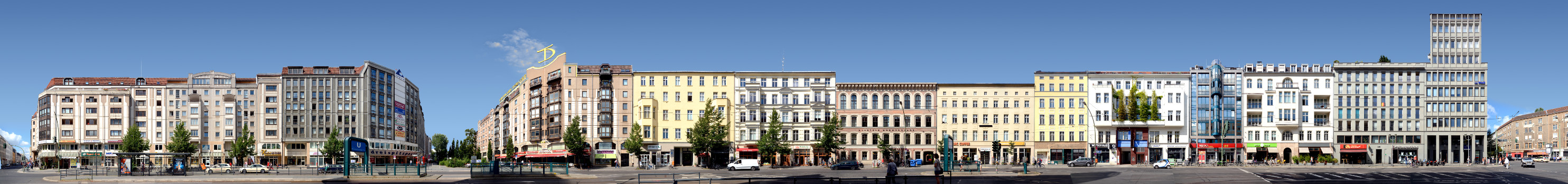
Until today the Kohlmarkt with its historical ensemble is the central meeting point of the city centre. A large number of the buildings were redesigned during the Gründerzeit era (Wilhelminian style) in the 19th century. Thanks to the prosperity of the time, older craftsmen’s and merchants’ houses were replaced by new buildings or their facades were redesigned decoratively. These new representative department stores on Kohlmarkt, as we can see on the panorama, were, in contrast to Braunschweig’s inner city, largely spared by war damage. For this reason, sixteen of the twenty buildings surrounding the marketplace count as cultural monuments.

Today, Kohlmarkt gives a varied image. The Wilhelminian “Haus zum Stern” at Kohlmarkt No. 2, shown here at the far right edge of the panorama, was built in 1894 in Neo-Renaissance style. Kohlmarkt 17 (second building from the left) also dates from this period, also with a facade designed in Neo-Renaissance style. Similarly, the façade of the classicistic Kohlmarkt 18 (third building from the left) from the 18th century was almost completely redesigned over the course of time.

Haus zur Sonne

Special attention should be paid to the historic “Haus zur Sonne” (= House to the Sun) at Kohlmarkt 19 (fourth house from left), which was built in the late 19th century. The massive stone building is one of the first of its kind in contrast to the half-timbered architecture that surrounded it at the time. Originally, the classicistic facade was rather sparsely decorated. In 1885 the building which originally was a two storey building with a high steep roof was rebuilt and its façade was decorated with Neo-Renaissance elements. It is probably only since this time that the sun symbol in the uppermost field of the gable has existed. The building was damaged by bombing during the Second World War, but was largely rebuilt and a third floor was added. The old company lettering “P.J. Blanck – Purveyor to the court” still reminds us today of Philipp Itzig Blanck and his flourishing textile business which was established here in the 19th century.

By the time of the panorama the shops in this street front included (left to right) the fashion House Koithan, Mode Herrmann, fashion store Jens Koch, Starbucks, Brax, Bijou Brigitte, and a TUI travel agency.

The post Kohlmarkt | Northside appeared first on PANORAMASTREETLINE.

Viewing all 36 articles
Browse latest View live


Latest Images